Rural CMA

Price rural land with comps that actually match the paddock

Agtuary CMA filters Australian rural sales by land use, soils, rainfall, production and distance - so valuers and agents stop defending residential-style evidence on rural files.
  • Full platform access
  • Cancel anytime
  • No setup fees
app.agtuary.com
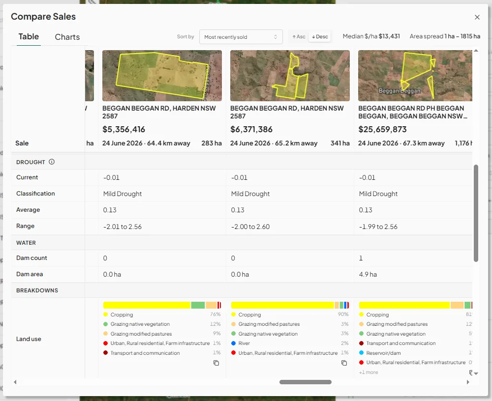
Compare Sales table showing median price per hectare, drought, water and land-use breakdowns for rural properties

Trusted by rural teams at

ColliersEldersCommonwealth BankSuncorpFindexREA GroupPropTrackBullagreen Finance
0+Years of market data
0M+Data points
0+Underlying data layers
MinutesNot months to a report
What you get

Comparable sales you can actually defend

Agtuary CMA filters Australian rural sales by land use, soils, rainfall, production and distance - from the same property record you use for due diligence. Find comps that share the land story, not just the map pin.

01

Comps that match the paddock

Filter sales by enterprise, soils, rainfall and land use - not just a radius around a pin - so the remaining comparables share how the country actually runs.

02

Land context next to every sale

Soils, rainfall and production sit beside the sale price in the same view - without joining GIS tools and a CMA by hand.

03

Ready for the listing or the credit file

Generate a CMA report with the comps mapped and ranked - ready for a vendor meeting, valuation or credit memo.

What's in a CMA

Comparable sales with the land sitting next to the price

Filter, rank and report rural sales from the same property record you use for due diligence.

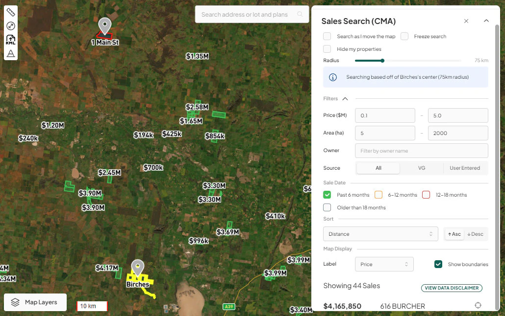
CMA map showing rural sale prices and search filters around Birches
01

Search rural comparables

Find sales by location, land use, area and enterprise - not just a radius around a pin.
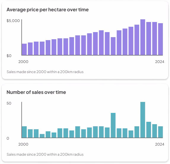
Charts of average price per hectare and rural sales volume from 2000 to 2024
02

Sales and listings kept separate

Historical sales and current listings stay distinct evidence. Asking price is not treated as a sold result.
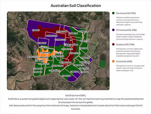
KYE soil classification map showing soil types across a rural property
03

Land and climate filters

Narrow the set by soils, rainfall, production and environmental characteristics so the remaining comps can actually be defended.

Compare Sales table showing median price per hectare, drought, water and land-use breakdowns for rural properties
04

Map and report output

See the comps on the map, then generate a professional CMA report for the valuation or the listing presentation.

How it works

Select the subject. Filter the market. Issue the report.

  1. 01

    Set the subject property

    Open the rural holding you are valuing or listing. The CMA starts from that record.

    CMA map showing rural sale prices and search filters around Birches
  2. 02

    Filter for land, not just distance

    Keep sales that share enterprise, soils, rainfall and production. Drop the ones that only look close on a map.

    Compare Sales table showing median price per hectare, drought, water and land-use breakdowns for rural properties
  3. 03

    Generate the CMA

    Export a report the vendor, the buyer or the credit file can actually use.

    Charts of average price per hectare and rural sales volume from 2000 to 2024
Market movements

Read rural market movements with confidence

CMA reports place land use, soils, rainfall and production context beside price. Review market movements for the property and its region.

Track market movements by property and region

  • Deep dive any property in the country
  • Understand price movements at a property and regional level
  • Benchmark value and price performance
  • Agtuary has partnered with REA Group to deliver live views of current & historical listings, sales history & ownership data
Sign up for a 7 day free trial

Average price per hectare over time

$5,000$020002024

Sales made since 2000 within a 200km radius

Number of sales over time

50020002024

Sales made since 2000 within a 200km radius

Similarity engine

A similarity engine dedicated to rural comparables

Nearby sales can differ sharply in land use and productive capacity. The CMA similarity engine ranks sales using the characteristics of the subject property.

app.agtuary.com
CMA similarity map with comparable rural sale prices and property markers
Comparable sales ranked by similarity to the subject property

Rank sales by property similarity

The ranking uses:

  1. 01Location information & property size
  2. 02Land cover, land use change & arability
  3. 03Seasonal & longterm rainfall patterns
  4. 04Yield and production performance
  5. 05Soil characteristics, classification & terrain
  6. 06Fire risk, fire history, heat stress, frost & temperature history
Sign up for a 7 day free trial
What changes

Stop explaining why the residential comps do not apply

Without Agtuary

  • Radius search that ignores enterprise and land quality
  • Sales in one system, soils and rainfall in another
  • Listings mixed through sold evidence
  • A CMA that has to be rebuilt for the next property

With Agtuary

  • Filters for land use, soils, rainfall and production
  • Sales and land context on the same record
  • Sold results kept separate from asking prices
  • A CMA report generated from the property you already opened

Unlimited CMAs on Professional

A CMA is $50 on the Free plan. Professional includes unlimited CMA and KYE reports, the inspection app, and the rest of the platform.

Compare plans →
Methodology

How rural comparable sales are identified

  1. 01

    Search starts from a subject property, title or location, then expands by geographic radius and rural land characteristics.

  2. 02

    Comparables can be filtered by land use, production, area, environmental attributes, listings, and settled sales so the set reflects how rural valuers actually adjust evidence.

  3. 03

    Soil, rainfall, land cover and fire history help explain why farms of a similar area can sell at different prices.

  4. 04

    Outputs include maps, tables, and exportable CMA reports for listing presentations and valuation files.

  5. 05

    The valuer or agent remains responsible for professional judgement and any formal valuation.

Limitations

  • Rural comparables are scarcer than residential sales. Thin markets, family transfers, and mixed-use holdings still require expert adjustment.
  • Listings and settled sales are different evidence types. Use both, and treat asking prices separately from recorded transactions.
  • Coverage of ownership and some attributes varies by state. Review the source, coverage and limitations before relying on a field for a statutory purpose.
The feedback from potential buyers on the in depth data that we can now provide with the Agtuary reporting system is a complete game changer, they are more confident in competing on a property when they have so much data to support their decision.
Rachelle Barnett, Elders Real Estate Young
Read the case study

Frequently asked questions

How is a rural CMA different from a residential CMA?
Rural comparables depend on land use, soils, rainfall, production and access to infrastructure. Agtuary CMA lets users filter sales by those rural attributes.
Can I use Agtuary CMA instead of a formal valuation?
No. CMA is market evidence and a workflow tool. Formal valuation remains a professional opinion prepared under the relevant standards.
What sales evidence does the CMA use?
The CMA draws on rural property sales data, current and historical listings, and property characteristics so you can compare settled transactions with market asking activity.
Get started

Find rural comparable sales

Use soil, rainfall, land use and transaction data to select comparables and export a CMA.